Software
GEMS Application Tool (GEMSAT)
■ Overview
GEMSAT is an intuitive software that provides specialized and dedicated functionality of plotting, visualizing, and analyzing space-based air quality data so that users can easily leverage satellite measurements to meet their specific needs.
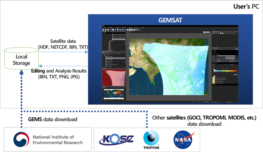
An application for dealing with remote-sensing data from GEMS and other satellites
- - A wide range of functionality (visualization/editing/analysis) for utilizing satellite data
- - Rigorous & comparative analysis of space-based air quality measurements
- - Able to save the results (image/data) of visualization and editing
Expertise not required
- - An easy-to-use user interface for non-experts
- - Stand-alone SW for research/education that runs on a desktop computer
- - Operational on Windows and Linux
Main features
- Satellite image control
- Satellite image display
- Measurement
- Synthesis
- Synchronization
- Navigation
- Area of interest
- Calculation
- Color editing
- Color map editing
- Rigorous analysis
- Filtering
- Image overlay
- Layer management
- Comparative analysis
- Time-lapse
- Map overlay
- Latitude/longitude overlay
- Map projection setting
- Data storage
- Cloud masking
- Isopleth overlay
Software
- - GEMSAT (Windows): GEMSAT_v103(windows).zip
- GEMSAT_v110(windows).zip
- - GEMSAT (Linux): GEMSAT_v103(linux).zip
- GEMSAT_v110(linux).zip
- ※ Update info(v110) : GEMS L2 Quality Flag, Macro, Vertical Charts
■ Program
- - GEMSAT Manual : Manual_v103_Eng.pdf
- Manual_v110_Eng.pdf
■ Explanation
Documentation
- - GK2B : https://nesc.nier.go.kr/en/html/cntnts/73/satellite/introduction.do
- - GEMS Introduction : https://nesc.nier.go.kr/en/html/cntnts/72/satellite/payload.do
- - GEMS Products : https://nesc.nier.go.kr/en/html/cntnts/59/outputs/overview.do
- - GEMS Operation : https://nesc.nier.go.kr/en/html/satellite/operation.do
- - How to Access GEMS Data : https://nesc.nier.go.kr/en/html/cntnts/91/static/page.do
- - Open-API Introduction : https://nesc.nier.go.kr/en/html/svc/openapi/explain.do
- - ATBDs (L2 products): https://nesc.nier.go.kr/en/html/satellite/doc/doc.do
■ See also: